Waterway Acidity

Waterway Acidity

Acidic groundwater is extensive throughout the Wheatbelt but most common and shallowest in the broad valley floors. The surface expression of acidic groundwater adversely impacts the condition of lakes and rivers by directly affecting aquatic life and mobilising trace elements and pollutants.

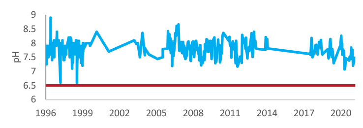
How can we monitor progress?

At Wheatbelt NRM Inc. we have searched for data that can help us monitor the status of waterway acidity. At a regional level we can report on the potential of acidic groundwater to enter waterways. At a local level we can follow the water quality of surface waters. 

Water quality in the lower Avon River

The graph shows the pH of surface water in the Avon River at Great Northern Highway (site ref: 616076) from July 1996 – September 2021.

Source: Department of Water and Environmental Regulation

River Function map

Click here to view the full map

Turn on the “Acidity Hazard” layer to see the risk (low, medium or high) of acidic groundwater entering natural waterways across the region.

Source: Department of Primary Industries and Regional Development

Stay Connected

Subscribe to our updates

Keep up to date on current events, funding opportunities and NRM in the Wheatbelt.

Left Column
Right Column